Author: Bill Calderwood
Edited: Annie Calderwood
Approving barks: Moxie Calderwood (DF hound)
{or how to reutilize an obsolete electronic boat anchor while learning something}
No this is not a story about transplanting the fine old British sport of fox hunting. This is about our seizing the moment, breaking away from a comfortable evening on the couch and relearning the tried and true art of Radio Direction Finding (RDF). Our story starts on Wednesday the 16th of February '00, when the Whidbey Island News Times announced that a new AM broadcast station would soon be taking to the air. The article explained that a group of broadcast radio lovers had acquired a bankrupt and heavily fined local radio station and would soon bring it back on the air to the expected advantage of all Whidbey Island residents. The newspaper article stated that the station, KWDB (1110 kHz), would begin test transmissions soon over the President's Day weekend. Like many things on this nearly remote island northwest of Seattle, schedules slip, and the station was not to actually begin broadcasting until Tuesday the 22nd.
Being new to Whidbey Island (I'd just moved from San Diego last summer), I had no idea where the radio station would be located. The opportunity to find the transmitter through RDF techniques presented itself; an opportunity for us the DF hounds to find the fox. But we would not be successful without planning and preparation. I needed to come up with a way to determine bearings to AM radio transmitters. I needed a way to measure these bearings in degrees true for plotting them on a chart. Of course a chart was another necessity. Finally, I needed a way of determining my own position with a high degree of accuracy - no guesswork here! My goal was to detect, locate by RDF, and sight the transmitter during its first day of operation.
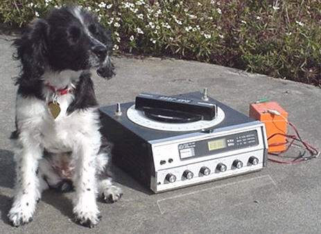
Determing bearing to an AM radio transmitter can be accomplished easily with any radio equipped with a ferrite loop antenna (FLA). This encompasses virtually all portable AM radios. Years ago a specialized RDF radio was developed to help mariners find the position of their boat by measuring and plotting bearings to known beacon transmitters. Since these beacon transmitters have been shut down in the wake of widespread Global Positioning System (GPS) use, these RDF radios are now obsolete - you can get them very cheaply or free. I found mine, a Ray Jefferson model 670, for less than $5.00 several years ago at a high school rummage sale (see figure 1). The R-J 670 features AM band, LF Beacon band, and FM band coverage with digital frequency readout and a large FLA for AM and LF. The FLA features a movable alidade (a 360 degree plastic circle around the FLA) with readout in two degree increments. The rotating FLA when oriented directly at or away from a transmitting station gives the user a signal null (minimum signal strength). The FLA gives the set very narrow nulls which allow bearing resolution to about +/- 2 degrees. Unfortunately, the FLA only works on AM and LF beacon band so bearing to FM broadcast transmitters are not possible with this receiver.
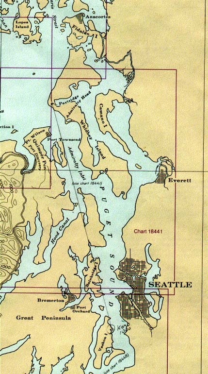
A key problem for finding an unknown radio transmitter is being able to determine a true bearing from at least three geographic positions. The true bearing is the catch. Without gyros or other paraphenalia, I could only derive a relative bearing with my trusty Ray Jefferson marine RDF set. The relative bearing was relative to however I had the set oriented. A magnetic compass solves this by having the North and South Magnetic poles as a reference; I needed a similar radio pole to reference by radio compass (RDF). To solve the relative versus true bearing problem, I surveyed existing charted AM and Non-Directional Beacon (NDB) transmitter locations to determine their predicted bearing to likely bearing sites on Northern Whidbey Island. The NDBs are air navigation aids similar, but generally lower power, to the now defunct marine navigation beacons. Unfortunately NDBs are not plotted on marine charts - you have to find an air navigation chart to locate them (see table 2). Only KOMO AM 1000 on North Eastern Vashon Island provided good signal strength from the transmitters I sampled. Though this transmitter was located over 50 miles away across land and sea it was the best reference I had to work with. Long range and intervening land-sea interfaces tend to degrade bearing accuracy. Using my trusty plotter and a navigation chart, true bearings to KOMO were measured from likely points where I planned to cut bearings against KWDB - see figure 2 and table 1. I planned to go to each DF site, obtain a DF on KOMO and set the alidade ring to the predicted bearing to KOMO. Doing this, the bearing alidade would be calibrated to true, yielding a true RDF bearing when I subsequently cut KWDB.
| Position | Bearing to KOMO |
| Home | 174 Degrees True |
| NAS | 170 |
| Keystone | 168 |
| Cranberry Lake | 171 |
| Sea Plane Base | 171 |
| Point Partridge | 165 |
| Freeland | 173 |
| Bush Point | 169 |
| San De Fuca | 166 |
Location |
Lat, Long |
Frequency |
Callsign |
Comments |
Lopez Island |
4829N, 12256W |
356 kHz |
OPZ |
SW Tip |
Friday Harbor |
4832N, 12303W |
284 kHz |
FHR |
N. base East Penn. |
Skagit Bay View |
|
240 kHz |
BVS |
W. of Burlington |
Kitsap (Bremerton) |
|
206 kHz |
PWT |
SW of Sinclair Inlet |
Ediz Hook |
|
317 kHz |
K |
Tip of the hook |
Neah Bay |
|
391 kHz |
EBY |
ESE of town |
Elwha |
4809N, 12340W |
515 kHz |
CL |
Joyce W. of Pt. Angeles |
White Rock |
|
332 kHz |
WC |
NNW of Blaine |
Renton |
|
353 kHz |
RNT |
South tip of lake |
Victoria |
|
200 kHz |
YJ |
8 NM N. of town |
Mason County |
348 kHz |
MNC |
N. of Shelton (2 NM) |
|
Abbotsford, BC |
344 kHz |
XX |
1 NM N. of border next to highway |
|
Okanogan |
396 kHz |
OMK |
North of town |
Obtaining a chart turned out to be surprisingly easy. Like many coastal resort areas, chart placemats are available for a small price. These allow the mariner to have a placemat for lunchtime and a back-up source for charting his position. Of course these placemats are covered with a glossy plastic finish and shouldn't be used for navigation purposes since they can't be kept up to date. But they certainly provide better navigation support than a road map or a travel brochure map. I got several of these for free at a garage sale. They are perfect for RDF work since they have latitude/longitude clearly marked and the glossy surface allows re-use with grease marker or VAP pen. One nice feature of these placemat charts is that they do include some of the larger roads on land. This will become important when we get to the point of tracking down the fox.
Once upon a time finding one's position on land required some orientiering skills. It was easy if you were at an intersection of two roads or some other distinctive feature plotted on a chart. But when you are in a hurry (trying to get a RDF fix on the station before it goes off the air at sunset), having a quick way of accurately determining your position in latitude and longitude at any position is a real help. Today cheap battery powered GPS systems are available which allow the user to find position to within 100 meters. My Garmin GPS-12 running on four AA flashlight batteries served this purpose admirably. It would acquire, lock-up, and display my position within about a minute upon arrival at each RDF position. We confirmed our position for each DF cut with the GPS to ensure highest accuracy.
At lunchtime on Tuesday the 22nd, I was out driving in my car. I routinely checked 1110 kHz to see if KWDB had finally started broadcasting. Success! 1970's/1980's rock music issued from the speaker where only static existed before! I could now execute the plan after work today. There wouldn't be much time, the predicted sunset time was about 5:45 p.m. and KWDB (only being licensed for daytime operation) would be obliged to suspend operations around sunset. After rushing home, Annie and I packed the RDF, charts, GPS, and Moxie the RDF hound into the VW van and went RDF fox hunting.
Starting at 5 p.m., we drove to the Sea Plane base and set up at the nature viewing area near the marsh. Since there were no picnic tables, the RDF was set up on the pavement in the parking lot. I got a bearing to KOMO and cranked the alidade ring to 170 degrees. Next we took a bearing to KWDB and measured B252/B072 degrees true. Two bearings are resolved with the FLA since it has two nulls separated by 180 degrees - the reciprocal bearing resolution problem. Bearing 252 made sense. While taking the bearing, Annie called my attention to an approaching Jeep. It was Base Security wondering exactly what I was doing. Luckily the patrolman understood what I was doing and departed promptly after determining that I was not a threat. Strangely the music coming out of the RDF set was different than that Annie was getting on the van radio. Why? Was I taking a cut on the wrong station? Rotating the FLA revealed that in the deep null of the RDF set, I was getting a skywave signal propagated in from somewhere else far away. This is one of the problems of DFing so late in the day, skywave reception can significantly distort RDF bearing measurement. Mariners used to call this and other associated effects Night Effect. RDF cut successfully obtained so now on to the next position, for time was running short!
We arrived at the NAS base picnic area at about 5:30 p.m. and set up the RDF on a concrete picnic table. Annie and Moxie enjoyed the beginnings of a fine sunset while I DF'd KOMO to get the true bearing reference. I corrected the alidade ring to read 170 degrees true on KOMO. Next, a DF to KWDB revealed a bearing of B193/B013. Bearing 013 made no sense so bearing 193 tells us the fox is south of Oak Harbor. Time to pick-up stakes and quickly move on to another location to get a third bearing for a fix. Note that you can get a good idea where a transmitter is by two RDF bearings. This is known as a two bearing cross (TBC) but since either bearing could be significantly in error it is not reliable enough to be called a fix. Three or more bearings are required for a fix. We hit the road exiting the Hospital gate of NAS Whidbey Island at about 5:40 p.m. The sun was setting, but we hoped that perhaps KWDB wouldn't be too prompt on terminating their broadcast day...
We parked the van at a beach overlook in the West Beach area and shot a quick bearing to KWDB. The station was extremely strong here. The final glow of the sunset revealed that we probably wouldn't have much time for another. Looking out to the east we'd seen radio towers with red aircraft avoidance lights near the center of the island. But these towers looked more like microwave than AM broadcast types. Our bearing at West Beach was B152/B332. In this case B152 made most sense. B332 was out in the strait of Juan de Fuca - not a likely location for a radio broadcaster. We had enough bearings now for a fix, but the station was still playing music and not giving any indication of going off the air. Deciding to see some more of the island previously unvisited we continued south towards Point Partridge to try for another DF cut.
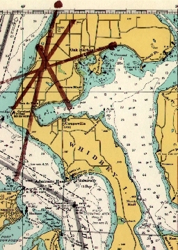
Arriving at Libby Beach (Point Partridge) at shortly after 6:00 p.m. we obtained another quick DF bearing with the RDF set up on the parking lot pavement. The Libby beach parking lot is down the hill quite a ways from the direction of our fox - I anticipated distortion of the bearing accuracy. It was dark now. I recorded my bearing for this location: B035/B215: bearing 035 made the most sense. Turning on the lights in the van allowed us to set up the chart on the table and plot the DF cuts with my VAP pen - see figure 3. The resulting fix was in the area of two major roads south of Oak Harbor. Unfortunately the roads are not named on the marine placemat chart being used for plotting. Comparing the roads with those shown on a roadmap revealed that the fix was near the intersection of Fort Nugent Rd. and Zylstra Rd. We bundled up our gear and set out to find the fox before it ceased transmitting. Amazingly it was dark and the daytime only station still played on with further hits from the 70's and 80's!
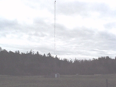
We drove down Fort Nugent road in the direction of Oak Harbor, and from out of the spruce trees we suddenly saw the red aircraft avoidance lights of a radio tower, just east of the intersection with Zylstra Rd. We'd found our fox see Figure 4! It was just like a World War II movie with the Gestapo rolling up in their RDF van discovering the location of the secret underground agent transmitter. KWDB is located in a fenced cow pasture not far from a residential area. It was late and we'd not had dinner yet, so we drove by after a quick satisfied glance, leaving further detailed viewing of the radio transmitter and antenna for another day. As we conducted errands in Oak Harbor we continued to monitor our successfully tracked down station with curiosity - when would they be shutting down? Finally, at 6:30 p.m., KWDB announced that they were concluding their test broadcast for the day and would return at 6:00 a.m. tomorrow. One of the items from the Whidbey News-Times indicated that the station under previous ownership had accumulated $80,000 in fines from the FCC. Gee, at this rate, if they continue as they've begun they'll be accumulating even more fines for operation outside their authorized daytime hours.
Return to Bill's homepage.